The “Myth” behind China’s Territorial Claims: Implications for Northeast India
The latest official map1of China shows large chunks of Indian Territory, especially in Arunachal Pradesh (AP), inside that country’s borders. This has triggered sharp responses from AP’s Chief Minister and also the central government. In November 2013, when President Pranab Mukherjee visited AP, the Chinese foreign ministry asserted that Arunachal Pradesh was established largely on three areas of China's Tibet region -- Monyul, Loyul and Lower Tsayul -- and termed it as ‘illegal’ occupation by India.2 China claims that “these three areas located between the illegal ‘McMahon Line’ line and the traditional customary boundary between China and India have always been Chinese territory”.3 Earlier in 2006, the Chinese ambassador to India claimed in New Delhi that the “whole of what you call the state of Arunachal Pradesh is Chinese territory”.4
Crosschecking Chinese Territorial Claims
Figure I: Historical ‘Monyul’, ‘Loyul’ and ‘Tsayul’ regions and China’s “traditional customary boundary”
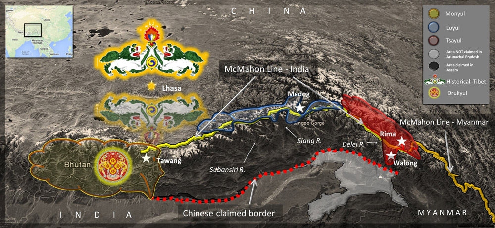
Source and Copyright: Namrata Goswami
‘Monyul’, ‘Loyul’ and ‘Tsayul’ that are claimed as ‘areas of China’s Tibet’ are historical Tibetan allusions for the regions south of the Eastern Tibetan frontier as opposed to China’s claimed ‘customary boundary line’. International boundaries based on delimited borders are a western concept of the modern sovereign state and did not exist traditionally in the historical East. The barren plateau of Tibet with its bleak and dry landscape ends at the towering southern barrier of the Himalaya mountain ranges watershed, where the regions of ‘Monyul’, ‘Loyul’ and ‘Tsayul’ were located (See Figure I). In sharp contrast, beyond the watershed, began the thickly forested borderlands inhabited by ethnic groups of the heavily rain-fed tropical Eastern Himalayas. The Tibetans historically defined the collective ethnic groups living in a section of the Himalayan region with a generic ethnonym -- ‘Monyul,’5 which was the ancient name for the southern borderlands, including the later Kingdom of Bhutan, which was then renamed Drukyul and its people the Drukpa after the mythical Bhutanese Thunder Dragon - Druk. Some of the ‘Monba’, the ethnic groups of earlier ‘Monyul’ region, were excluded from Bhutan’s borders in the east (See Figure I). The ethnic groups of ‘Loyul’ region would be the ‘Lopa/Lhoba’ and ‘Tsayul’ region were the ‘Idu Lhoba’ and the ‘Dengpa’. These exonyms like ‘Monba’ was deprecating and ‘Lopa’ was highly pejorative 6of archaic origin and usage in the Tibetan language, however, listed as such in the ethnic groups of China today7. The Chinese government does not officially recognize the ‘Dengpa’ as an ethnic minority and continues to use the old offensive Tibetan exonym for the people of ‘Tsayul’.
The Chinese claim that these three areas, located between the McMahon Line and the traditional customary boundary between China and India, have always been Chinese territory (See Figure 1).8 Historically, the Tibetan authorities did not have direct administrative control over the southern regions and borderlands beyond. Tibetan agents started appearing along the frontier at the turn of the twentieth century, engaging in mutual pillaging expeditions with non-Tibetan and non-Buddhist ethnic groups using tactics of threats, intimidation and violence. As an illustration: In the 1930s, Tibetan raiding parties from the outpost at Medog organized hundreds of ‘Memba’(immigrants from Eastern Bhutan) settlers armed to the teeth who travelled down the Siang River looting and enslaving ‘Lopa’ villagers along both the riverbanks (See Figure I). The roles were reversed down the Subansiri River (See Figure I), where Tibetans paid ‘protection money’ (usually goods of value and other valuables) to the ‘Lopa’ for safe passages for pilgrimage to the most sacred Buddhist sites through the territories of the ‘Lopa’. The arrangement often broke down due to ‘nonpayment’ by the Tibetans resulting in retaliatory attacks by the ‘Lopa’ on Tibetan pilgrims.9
The sixth Dalai Lama was born10 near the Tawang monastery, whose mother was of ‘Monba’ royalty and the father a descendant of a famous Bhutanese saint. The ‘Monba’ adopted Buddhism in the 17th century when the Buddhist monk Lama Mera from Bhutan founded the Tawang Monastery under orders from the Dalai Lama.11 The Chinese Emperor Kang Xi had Mongol assassins murder the Dalai Lama on his way to Beijing, an attitude towards the Tibetan spiritual leader evident even to this day.12 The invaders attacked Tibet, Bhutan and Tawang, especially destroying and obliterating memorials and the monastery of the ‘Monba’ Dalai Lama in a futile attempt to obfuscate Tibetan history.13
Likewise, it was in the twentieth century, for the very first time that the Manchu army led by General Zhao Erfeng14, who was notorious amongst the Tibetans and later executed, invaded ‘Tsayul’ with troops camping at Rima (See Figure I). The Chinese planted boundary flags at Walong in the summer of 1910 and the next year threatened the ‘Dengpa’ in the upper reaches of the Delei river (See Figure I), after which the British secured the Assam-Tibet border with the Simla boundary agreement in 1914.
In the 1960s China used the ‘illegal’ McMahon Line (See Figure I) to delimit the boundary for a border agreement15 with Myanmar. So while the territory demarcated by the McMahon Line in Myanmar is undisputedly recognized by China as legitimate part of that sovereign neighboring state, the adjacent Indian territory starting right at the Indo-Myanmar border and demarcated by the same McMahon Line is disputed as ‘under illegal Indian Occupation’. There are other inconsistencies regarding the ‘traditional customary boundary’ between India and China. The Chinese claims do NOT extend to ‘the whole of what we call Arunachal Pradesh’ and does not include territory in the far eastern corner of the state. The ‘traditional customary boundary’ also slices through strips of land inside the state of Assam bordering AP, which the claimant misses out upon (See Figure I).
Implications for Northeast Ethnic Groups
As a consequence of the contested claims by China, the ancestral homelands and the national identity of many ethnic groups of AP and Assam have come under implied threat. In a scenario of compromised borders, ethnic groups in the affected areas stand to lose their identities and way of life that their ancestors have always fiercely defended. There is the insinuation of these tribes from the Northeast (See Figure II) getting divided by imposed boundaries, a situation already faced by other ethnic groups like the Nagas in their own fragmented homeland. To state a few illustrations, the Chinese border claims arbitrarily cuts up and splits the territory of the Tani people consisting of the Adi, Apatani, Nyishi, Tagin and Mishing ethnic groups in AP. Many Mishmi people in the past have already migrated to India to live amongst the majority of their ethnic brethren. All this will be undone as per China’s scheme for delimiting the international border, slicing and dicing the Mishmi homeland (see Figure II).
Figure II: Distribution of Major Ethnic Groups under Threat
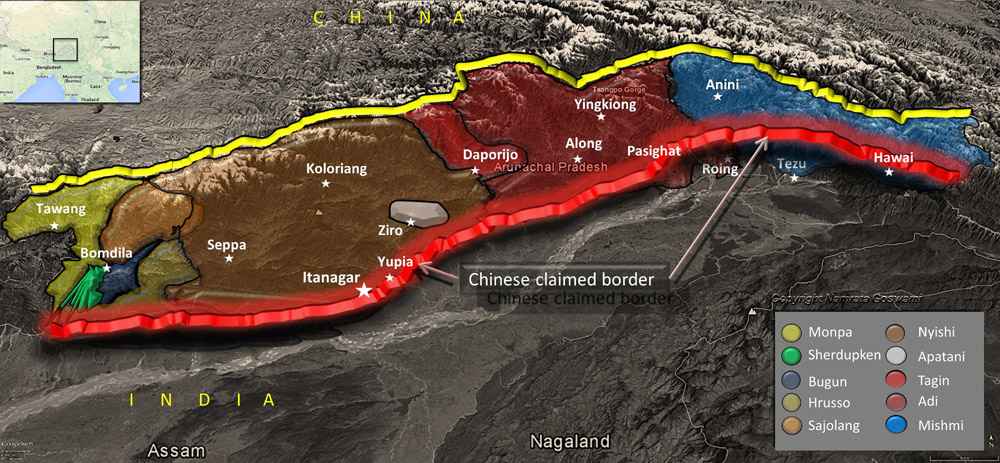
Source and Copyright: Namrata Goswami
Security Assessment of the Northeast
In spite of the ongoing border talks between the two countries, China does not desist from bringing out the disputed territorial issue in public whenever top Indian leaders visit areas claimed by the Chinese. These are propaganda tactics to draw media attention to territorial claims by China, which substitute for genuine facts as well as attempts to instill fear amongst the local ethnic groups. The issuance of stapled visas to Indian citizens who are perceived by China as domiciles of the claimed areas for instance is an extension of such tactics. The Chinese have also displayed a pattern of timed intrusions at the Line of Actual Control (LAC) before impending or around high level meetings between leaders16 to pressurize and garner points at the table, a fact which speaks volumes of China’s intentions to honor earlier good conduct border agreements.
Of great concern are the incursions in the claimed Indian Territory by the People’s Liberation Army (PLA), to assert dominance taking advantage of an undemarcated international border and superior logistics against the Indian military. In addition to incrementally gaining territory17 at the LAC, such underhanded tactics have the effect of scaring settled population near the LAC. As an illustration of these tactics, in the past years, the PLA has been intruding inside AP at Chaglagam circle in Anjaw District (See Figure III). The LAC is located over 100 km by surface beyond the last Indo-Tibetan Border Police (ITBP) patrol post with no motorable roads, which enables the PLA to cross over the border unchallenged. The latest incident happened in August 2013, when a large intruding Chinese patrol party armed with electro-shock and sophisticated weapons stayed put for several days in the abandoned Phomphom village18 and reportedly refused to vacate when challenged by the Indian patrol. The Chinese always paint the rocks and trees with signs and symbols, which are promptly defaced by the next Indian military patrol. China’s intrusion motives are to ostensibly intimidate local Indian citizens of the Mishmis and affiliated Zekhring ethnic groups who have moved out of the LAC’s proximity from the other evacuated villages of Najong, Thenya and partially at Taflagam19 and Asiliang.
The greatest disruption to the daily lives of citizens in the Northeast can come from China’s unilateral plans to completely divert the upstream Yarlung Tsangpo River in the Tibetan Autonomous Region (TAR), which is called the Siang and the Brahmaputra River downstream in India (See Figure III).20 There have been concerns raised by states of AP and Assam21 about existing dams on the river built by China in TAR.
The PLA uses high technology of networked and remote-controlled surveillance systems at the LAC as opposed to the mannedvigil of the Indian Army functioning under pressure to thwart incursions. While the TAR is open, barren and flat, the landscape gets mountainous eastward opposite Northeast India. The PLA has, however, positioned Main Battle Tanks (MBT) at the LAC along with high altitude acclimatized soldiers. Further north in the TAR flows the Yarlung Tsangpo River, over which the PLA conducts regular wartime river crossing support drills. Gravel roads from inside the TAR to the LAC allow better water drainage during the heavy monsoons in the Eastern Himalayas as well as flying under the Indian radar. The PLA’s Construction Corps has taken full advantage of these gravel roads and their capabilities of quickly converting gravel roads to black topped whenever required.
The brigade-sized Rapid Reaction Forces (RRF) or the Resolving Emergency Mobile Combat Forces (REMCF) is the PLA’s customized ‘fist’ strike force for quick deployment anywhere within the TAR through the network of helibases, helipads and supporting border surveillance systems, medium-lift helicopters, light armed aeroscouts and attack helicopters. For example, the Regimental Headquarters at Tsona Dzong opposite Tawang, has just a brigade of the Border Defense Regiment and is well-connected to Lhasa via all-weather roads as well as an oil pipeline and can quickly mobilize assets by ferrying RRF to the LAC (See Figure III). The PLA deployment on the LAC opposite AP is drawn from the General Army bases in Yunnan. Interestingly, the flanking maneuvers of airborne units combined with jungle warfare training of the PLA personnel deployed in this sector, have been strategized to unleash the blitzkrieg effect to achieve victory with short intensive warfare.
China has built large dual-use airports near the LAC opposite Northeast India at Shigatse Pingan, Lhasa, Nyingchi, and Qamdo. The surface transportation backbone in the TAR close to the eastern LAC includes a network of highways (See Figure III). Under construction are new railway lines connecting Lhasa to Shigatse, Yatung and Linzhi near the LAC in the finger area of Sikkim. Another new railway track is under construction from Lhasa to Nyingchi running near and parallel to the LAC in Arunachal Pradesh, and extending to Chengdu (See Figure III).
The PLA has permanently deployed ballistic missiles in contiguous Chinese territory and within range of Northeast India like the underground storage complex for ground to air and surface to surface missiles at Bayizhen right near the LAC (See Figure III). Another secret massive tunnel construction was reported at Yadong opposite Sikkim. These missiles can be targeted at Indian air and ground assets across the LAC. The missiles on mobile launchers using hardened highway networks in Tibet have reportedly been readied for tactical nuclear warheads in the aftermath of the US’s ‘Asia pivot’ push.22
Figure III: Landscape of Chinese Activity
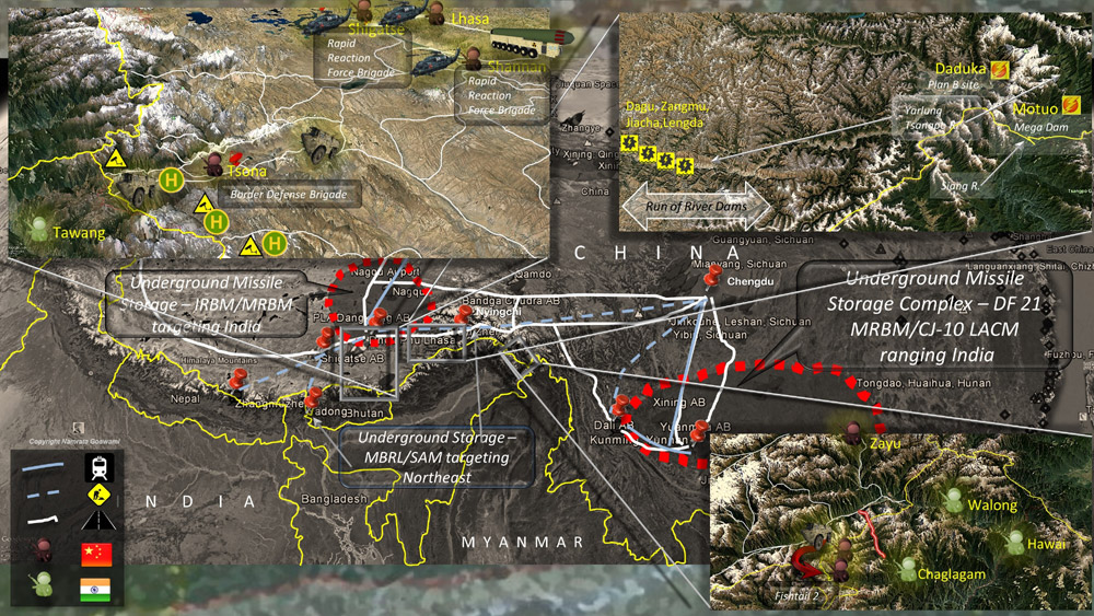
Source and copyright: Namrata Goswami
Settlement of a Modern International Boundary
It is unnatural and detrimental for international relations to have an un-delimited and unsettled border between two large neighbors. While India and China have had the longest span of negotiations on the border issue, what seems to be impeding final resolution is a lack of sincerity and strong commitment from both the stakeholders. There have been some progress made in the past in defining a framework of principles for delimitation of the boundary. But achieving a common ground for hammering out a mutually agreed upon solution has proven elusive as national geopolitics gain importance. A perceived lack of respect (through words and actions) of one stakeholder easily translate to the other’s heightened threat perception. While pursuing national interest is a legitimate activity for any sovereign state, in dealing with thorny bilateral issues, nations have to demonstrate mutual respect to earn mutual appreciation of respective positions. Resorting to coercive military maneuvers and intimidated geopolitical tactics could result in disastrous consequences, especially for neighbors like China and India with a long disconcerted borderland.
- For more see, “New China map shows Arunachal Pradesh as part of Tibet”, India Today, June 28, 2014, http://indiatoday.intoday.in/story/china-map-shows-arunachal-pradesh-as-part-of-tibet/1/369022.html (Accessed on July 15, 2014.
- Ananth Krishnan, “China reiterates Claim on Arunachal”, The Hindu, December 01, 2013, http://www.thehindu.com/todays-paper/tp-national/china-reiterates-claim-on-arunachal/article5409591.ece (Accessed on August 11, 2014).
- See, “China urges India not to complicate border issue”, Xinhuanet, November 30, 2011, http://news.xinhuanet.com/english/china/2013-11/30/c_132931034.htm (Last accessed on July 16, 2014)
- Surya Gangadharan, “Arunachal is Chinese land: envoy, CNN-IBN, November 20, 2006, at http://ibnlive.in.com/news/arunachal-is-chinese-land-envoy/26108-3.html (Last accessed on July 16, 2014)
- See, Bhutan Country Study Guide, Volume 1, Washington.D.C: USA International Business Publications, 2002, p. 58.
- See, Tsering Gyalbo, Hazod and Sørensen, Civilization at the Foot of Mount Sham-po, The Royal House of lHa Bug-pa can and the History of gYa-bzang’, 2000, pp. 54-55.
- Khrili Chodra, et.al., Tibet, Buchclub Ex Libris, 1983.
- Krishnan, n. 2.
- See F.K. Ehrhard, ‘Political and ritual aspects of the search for Himalayan sacred lands’, in T. Huber (ed.), Sacred Spaces and Powerful Places in Tibetan Culture, Dharamsala: Library of Tibetan Works and Archives, 1999, pp. 227-57.
- For more see, “The Sixth Dalai Lama Tsewang Gyaltso”, at https://web.archive.org/web/20070610044909/http:/namgyalmonastery.org/hhdl/hhdl6 (Accessed on August 09, 2014).
- See, Gyume Dorje, Footprint Tibet Handbook with Bhutan (England: Footprint Handbooks, 1999), p. 200.
- For more see, “China warns Dalai Lama not to jeopardize Tibetan Buddhism, motherland unification”, People’s Daily, March 07, 2012 at http://english.people.com.cn/90785/7750630.html(Accessed on July 18, 2014)
- See Glenn H. Mullin, The Fourteen Dalai Lamas: A Sacred Legacy of Reincarnation (Santa Fe, New Mexico: Clear Light Publishers, 2001), p. 274
- See Jamyang Norbu, Warriors of Tibet: the story of Aten, and the Khampas' Fight for the Freedom of their Country (London: Wisdom Publications, 1986), p. 28
- For more see, “International Boundary Study, No. 42 – November 30, 1964; Burma – China Boundary”, at http://www.law.fsu.edu/library/collection/limitsinseas/IBS042.pdf (Accessed on July 14, 2014).
- See, “Chinese Troops cross LAC in Ladakh again, India Today, July 16, 2014 at http://indiatoday.intoday.in/story/chinese-troops-cross-lac-in-ladakh-again/1/372631.html (Last accessed on July 18, 2014)
- For more see, Brahma Chellany, “China’s salami-slicing strategy”, Japan Times, July 25, 2013 at http://www.japantimes.co.jp/opinion/2013/07/25/commentary/world-comment… (Last accessed on July 17, 2014)
- “PLA soldiers still camping in Arunachal”, Echo of Arunachal, August 22, 2013 at http://www.echoofarunachal.com/?p=39940 (Last accessed on August 3,2014)
- Nishit Dholabhai,“After border, a village, not vigilante post- Arunachal hamlet tells ITBP to move closer to McMahon line after Chinese incursions”, at http://www.telegraphindia.com/1091025/jsp/nation/story_11655832.jsp (Last accessed on August 03,2014)
- For more see Gabriel Lafitte, Damming Tibet to Save China: Hydropower's Coming Golden Decade, at http://www.tibetanpoliticalreview.org/ articles/dammingtibettosavechinahydropowerscominggoldendecade (Last accessed on July 16,2014)
- Arunachal, Assam concerned about Chinese dams, Rediff, February 09, 2013 at http://www.rediff.com/news/report/arunachal-assam-concerned-about-chinese-dams/20130209.htm (Last accessed on July 16, 2014)
- For more see, Richard Fisher, Jr.,“Less Is Not Enough: Reflections on China’s Military Trajectory and the U.S. Pivot”, at http://www.strategycenter.net/docLib/20121125_FisherLessisNotEnough112512.pdf (Accessed on July 18, 2014)